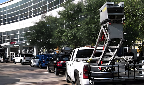
Mobile Terrestrial Laser Scanning
Link to pdf here.
| Benefit | High accuracy, feature-rich point clouds obtained from within a vehicle moving at highway speed. Keeps surveyors safe as they are not exposed to traffic. Supports “survey on demand” by extracting desired features and attributes from the point cloud without the need to return to the field for measurements. |
AHMCT researchers are working with Caltrans Office of Land Surveys to study Mobile Terrestrial Laser Scanning (MTLS) and its applicability for surveys, pavements, bridge structures, roadside assets, and other Caltrans applications areas. The work includes development of best practices, methods for accuracy improvements, and tools for feature and attribute extraction.
Why We Pursued This Research
Surveyors are exposed to high-speed traffic, often with no positive barrier or protection, putting them at high risk when surveying the highway. MTLS provides a tool for surveyors to do their job in an innovative way while working safely from a vehicle moving at highway speed. In addition to the clear safety improvement provided, MTLS provides multiple efficiency improvements. First the collection occurs at highway speed so that many miles of roadway can be collected in a single day. Second, the system collects location, image, and intensity for a huge number of points every second, generating a so-called point cloud. Using this point cloud, surveyors, engineers, and others can extract information, for example dimensions, while in the office, removing the need to return to the field for measurements. Availability of the point cloud enables innovative applications including visualization and virtual design and construction.
What We Are Doing
AHMCT is working in four main areas for its MTLS research.
• AHMCT is developing best practices and workflows for MTLS. This includes working with a large number of software packages to determine their features, strengths, and areas for improvement. Each software package is being documented to illustrate the best workflow for that package in appropriate Caltrans applications and deliverable requirements. We are also working with Caltrans to document best field practices for MTLS, and have contributed to Chapter 15 in the Caltrans surveys manual.
• AHMCT examined a few MTLS data sets and compared them with data collected using total station, digital levels, or stationary laser scanner. We have assessed point cloud accuracy provided by a few MTLS systems. While MTLS is very accurate in general, there are a number of sources for errors in the solution, and thus room for accuracy improvements. AHMCT is investigating methods for improving the accuracy of MTLS.
• AHMCT is collecting cost data from various Caltrans and other DOT projects using MTLS. At the same time, we are assessing the benefit of MTLS to various Caltrans applications. These data are used for cost-benefit analysis for various deployment methods and applications.
• Finally, AHMCT is investigating methods and tools for feature and attribute extraction from the point clouds generated by MTLS. These methods and tools are specifically targeted to extract the type of features and attributes in key Caltrans applications. Application areas include surveys, pavements, bridge structures, and roadside assets. The result will be open-source software available to Caltrans and other State DOTs.
For Additional Information
| Bahram Ravani Principal Investigator |
bravani (at) ucdavis.edu | (530) 754-6130 |
| Ty A. Lasky Co-Principal Investigator |
talasky (at) ucdavis.e du | (530) 752-6366 |
| Kin S. Yen Primary contact |
ksyen (at) ucdavis.edu | (530) 754-7401 |
This document is disseminated in the interest of information exchange. The contents do not necessarily reflect the official views or policies of the AHMCT Research Center, the University of California, the State of California, or the Federal Highway Administration. This document does not constitute a standard, specification, regulation, or imply endorsement of the conclusions or recommendations.
(rev. Oct, 2012)