
3D Laser Scanning
AHMCT researchers have developed a coordinated set of standards and specifications for the use of laser scanning in Caltrans. This enables large-scale deployments of 3D scanning into survey operations, improving efficiency and safety. #D as-built models will enhance highway design, construction, and maintenance.

Advanced Snow Plow
Developing improvements in sensor technology, algorithms, displays and system design, provides a fully integrated system to significantly improve the safety and efficiency of winter maintenance, one of the most demanding and safety-critical areas of highway maintenance.

Automated Raised Pavement Marker Machine
The development of an automated raised pavement marker machine reduces the cost associated with raised pavement marker installation. Also, worker safety and injury prevention will be greatly improved.

Automated Travel Diary
AHMCT researchers, in conjunction with the Caltrans Division of Transportation System Information, have developed a prototype GPS-Automated Travel Diary (GPS-ATD) to replace traditional paper-and-pencil and computer-assisted approaches for travel surveys. The GPS-ATD minimizes the user burden during longitudinal travel behavior surveys, while providing accurate, reliable, and spatially dense traveler behavior data at a significantly reduced cost.

Bridge Profiling
AHMCT researchers have developed a deployable prototype system for bridge profile sensing from a vehicle at highway speed, i.e. with no fixed or rolling closure. The system uses a scanning laser to measure range and reflected power from the bridge and the roadway. The laser data is analyzed by custom software to determine bridge height measurements, as well as lane widths and other horizontal dimensions. The software includes a user interface for interactive fine-tuning of the results. These dimensions can then be used to update a two-dimensional profile of the bridge and the corresponding databases in support of oversize vehicle permit generation. The tool facilitates producing standard Caltrans clearance diagrams from the extracted dimensions.

Cone Machine Overview
The AHMCT Cone Machine is a safe and efficient method of placing and retrieving highway cones during roadway lane closures. A single operator can safely and quickly open and close busy lanes during construction or maintenance.

Debris Removal Attachment
Develop a machine as a removable truck attachment to collect garbage bags placed on roadsides by litter cleanup crews, with the added feature of lifting up to a 100lb single object, such as a deer carcass. Which results in improving safety of workers collecting trash bags by reducing worker exposure to traffic with the ability to pickup bags without leaving the vehicle. This also reduces worker lifting injuries and reduces costs since it does not require a dedicated vehicle.

GPS Automated Travel Diary (GPS-ATD) Enhances Travel Behavior Surveys
AHMCT researchers, in conjunction with the Caltrans Division of Transportation System Information, have developed a prototype GPS-Automated Travel Diary (GPS-ATD) to replace traditional paper-and-pencil and computer-assisted approaches for travel surveys. The GPS-ATD minimizes the user burden during longitudinal travel behavior surveys, while providing accurate, reliable, and spatially dense traveler behavior data at a significantly reduced cost.

GPS Differential Signals
AHMCT researchers are developing a wireless network-based approach for delivering precision GPS differential correction signals to vehicles. This system enables novel applications requiring decimeter or centimeter-level accuracy, and removes the need for a dedicated RF license. It leverages emerging wireless standards and infrastructure. In addition, the significant remaining bandwidth can support many other applications, such as using vehicles as probes for traffic management.

Labor Intensive Manual Tasks
AHMCT is researching the roadside maintenance work environment to identify cost-effective deployable improvements to methods, equipment, and processes that will lessen worker injuries, increase worker effectiveness and support Caltrans goals of safety and stewardship.

Longitudinal Crack Sealing
The Longitudinal Crack Sealing Machine (LCSM) program is dedicated to the development of automated sealing machines for relatively continuous longitudinal cracks, such as those that occur between a concrete lane and asphalt shoulders. The machine pictured here is the second generation Longitudinal Crack Sealing Machine (LCSM2) operated by Caltrans Maintenance crews in the Fresno area.

Magnetometer Sensing and Control
AHMCT researchers have developed an intelligent sensing system for detecting road-embedded magnetic reference systems. The system addresses drawbacks of previous research prototypes, and moves magnet-based vehicle guidance and control closer to real- world application. The patented system works for both discrete embedded magnets and continuous magnetic references, i.e. “tape,” and can be applied in highway maintenance, transit, commercial vehicle, loading, factory, and airport operations. The design and algorithms developed in this research are patented and are available for licensing through the UC Davis Office of Technology Transfer.

Mountain Pass Opening
AHMCT researchers are developing a driver assistance system for mountain pass opening. The portable system provides the operator with a display indicating location and height above the road, vehicle heading, and system status. Sensing is provided by GPS with satellite-based differential corrections, along with a dual-antenna GPS-based compass for heading.

MTLS(Mobile Terrestrial Laser Scanning)
AHMCT researchers are working with Caltrans Office of Land Surveys to study Mobile Terrestrial Laser Scanning (MTLS) and its applicability for surveys, pavements, bridge structures, roadside assets, and other Caltrans applications areas. The work includes development of best practices, methods for accuracy improvements, and tools for feature and attribute extraction.

Python Pothole Repair
Through the general deployment of automated pothole patching machine to Caltrans maintenance operation, AHMCT strives to increase both the safety and quality of highway pothole patching operations.
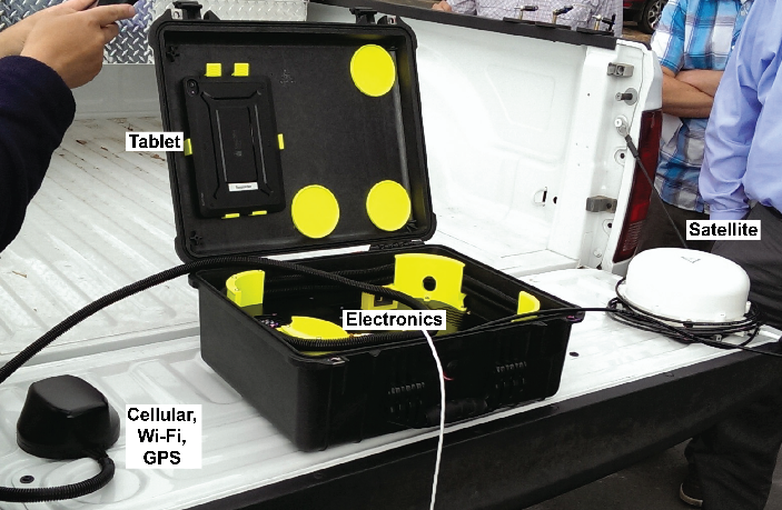
Responder
AHMCT researchers have finalized the third generation of the Responder system, a communication tool that integrates hardware, software, and communications to provide incident responders, particularly those in rural areas with sparse communication coverage, with an easy to use means to accurately collect and communicate at-scene information with their managers and the TMC. This resulted in allowing first responders to provide information to get the right equipment and personnel dispatched to the site, effectively utilizing resources.
Roadside Inventory
This user-friendly graphical navigation tool, combined with available automated data collection systems, will allow inventory and assessment in a fraction of the time it would take to do in any other way. The asset management system can provide comprehensive data that can be used in conjunction with existing databases or Geographical Information Systems (GIS). It provides a cost-effective solution to the task of navigating inventory for large numbers of roadside features in times of shrinking budgets.

Sealzall Crack Sealer
The introduction of innovative crack sealing equipment capable of high production automated longitudinal sealing and enhanced manual in-lane crack sealing operations into Caltrans statewide Maintenance operations. This results in a dramatic increase in both production and safety for highway pavement sealing operations, while also reducing traffic obstruction.

Self-Contained Traffic Hazard Monitoring
Through expanding the utilization of self-contained vision based sensor systems which can easily be configured and deployed to monitor a wide range highway sites, this provides Caltrans traffic engineers with an automated web-based traffic monitoring device to assist in the study and mitigation of hazardous highway traffic locations

Tow Plow Pilot
A Tow Plow is a plow truck attachment much like a wing plow which enables a truck to clear two full lanes of highway in a single pass. The configuration and capabilities of the plow truck is the key element which will dictate the long-term success of the Tow Plow in Caltrans winter highway operations.

Traffic Management System
AHMCT researchers are demonstrating the application of an Advanced Traffic Management System (ATMS) based on open standards, open software, and commodity computer hardware. This approach can greatly reduce ATMS deployment and maintenance costs, freeing funds for additional ATMS deployment. This approach also benefits public safety and mobility by enabling ATMS installation in remaining Caltrans districts at relatively little incremental cost.