
Best Practices in Roadside Inventory Assessment
Link to pdf here.
| Outcome | Recommend products and practices, and develop the requirements for an inventory tracking and asset management tool. Deliver: June 2008 |
|---|---|
| Benefit | Identify best inventory tracking practices around the country, and provide administrators with tools and requirements for inventory asset management. |
This project has two parts. The first part involves performing a literature search and a user survey to develop an understanding of the state-of-the-art in roadside inventory for Caltrans use. The second part will identify best practices and develop a set of recommended practices for Caltrans that would capture experience learned from Phase 1 and take advantage of available technologies. As part of Phase 2, some experiments will also be made in developing the kernel of a software-based asset management tool for Roadside Inventory Assessment. Such a tool when fully developed will provide Caltrans with a method to track inventory of roadside features. This user-friendly graphical navigation tool, combined with available automated data collection systems, will allow inventory and assessment in a fraction of the time it would take to do in any other way. The asset management system can provide comprehensive data that can be used in conjunction with existing databases or Geographical Information Systems (GIS). It provides a cost-effective solution to the task of navigating inventory for large numbers of roadside features in times of shrinking budgets.
Why We Are Pursuing This Research
The inventorying of roadside and overhead facilities along the nations highways is becoming an important issue for infrastructure management by public works administrators. With increasing demands to regulate ever growing traffic densities together with shrinking budgets, traditional methods of highway inventorying are simply too inefficient. In addition, it is important to be able to quantify roadside maintenance costs in order to develop future budgets.
Highway facilities, using signs as an example, may be subject to regulations or specification, in terms of their size, positioning, or visibility. Consequently, to verify that a single sign is appropriately situated may require manual measurements of the sign’s position with respect to a mileage reference marker, and the object indicated by the sign. The offset from the edge of the highway, and the height of the sign above the pavement may also be important. To measure these parameters is a time consuming and costly manual exercise. Furthermore, it may be necessary from time to time to verify that the sign has not deteriorated to the point where its visibility is compromised, or become vandalized, or damaged from snow plowing. From the viewpoint of protection from future litigation, a pictorial record of compliance may be prudent.
All this effort is costly in terms of man-hours and dollars, requiring not only the time to make these measurements, but also the time involved to travel to and between sites. In addition there is risk to worker safety when working and parking vehicles on the shoulders of busy highways. And, after all of that, the data collected from this intensive investigation (of a single sign) needs to be entered in some type of database management system.
To adequately address the need for inventory and measurements, a radically new solution is required; a solution divorced from manual field measurements, and one that is for the most part automated.
What We Are Doing
In the first phase of this research, AHMCT performed a literature search and a user survey to develop an understanding of the state-of-the-art in roadside inventory for Caltrans use. This phase identified best inventory tracking practices around the country. These results will feed into the second phase of the research.
In Phase 2, AHMCT researchers will identify best practices and develop a set of recommended practices for Caltrans that would capture experience learned from Phase 1 and take advantage of available technologies. As part of Phase 2, some experiments will also be made in developing the kernel of a software-based asset management tool for Roadside Inventory Assessment. Such a tool when fully developed will provide Caltrans with a method to track inventory of roadside features.
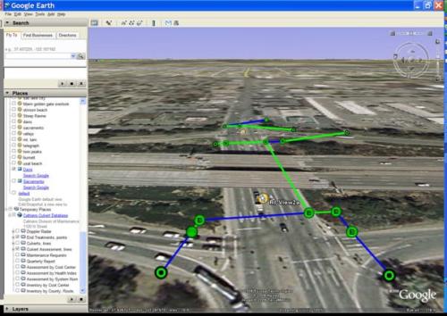
The envisioned interface, as shown in Figure 1, will have:
- A menu bar that functions similar to other graphical applications.
- The image area where the roadside feature is displayed.
- An object record area that displays appropriate feature data.
The application areas where this software can be used for roadside feature navigation include:
- Landscape and Vegetation — The software will allow users to easily identify rich landscapes as part of the maintenance planning process, including around guardrails, bridge columns and areas where equipment cannot access. The interface can provide data of species and habitats in the landscape.
- Culverts & Drainage
- Sign Management
- Guardrail Inventory — With this type of application, the user can easily identify guardrail locations and offsets, along with a variety of attributes.
- Bridge Inventory — Bridge data can be visualized with the software.
- Location-based viewing of Historical Record — A visual historic record provides an agency with a fair-weather view of its pavement and right-of-way. It can also be used to monitor pavement or feature deterioration over time. The asset management tool can interface with existing photolog-based historical records.
Current Status
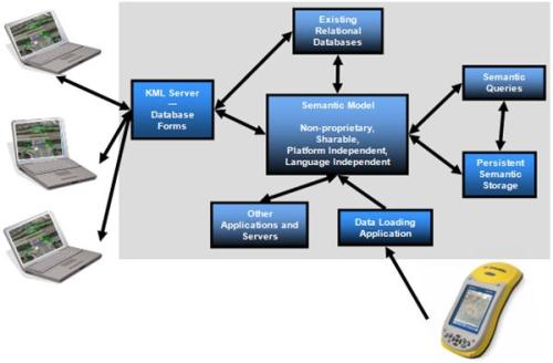
A roadside inventory questionnaire was distributed to identify the roadside features that are inventoried and understand methods for inventory and condition monitoring within Caltrans and other DOT’s nationwide, and the results have been analyzed and summarized for Caltrans. In addition, a detailed technology landscape of existing methodologies and best practices amongst commercial vendors is complete. Initial feedback from Caltrans has been positive, and AHMCT researchers are reviewing commercially available tools to monitor and assess roadside features, and have initiated development of the kernel of a software asset management tool and a visualization wizard. AHMCT researchers are also working with Caltrans to enhance data collection methodologies, and improving capabilities for storing collected data (e.g. on landscape features) back to existing Caltrans databases, as well as the AHMCT asset management tools.
For Additional Information
- Larry Baumeister — (916) 227-5835, [email protected], Caltrans Project Manager
- Bahram Ravani — (530) 754-6130, [email protected], Principal investigator
- Ty A. Lasky — (530) 752-6366, [email protected], Co-Principal investigator
- Jagannath Hiremagalur — (530) 752-3900, [email protected], Primary contact
| Larry Baumeister Caltrans Project Manager |
Larry_Baumeister (at) dot.ca.gov | (916) 227-5835 |
| Bahram Ravani Principal investigator |
bravani (at) ucdavis.edu | (530) 754-6130 |
| Ty A. Lasky Co-Principal investigator |
talasky (at) ucdavis.edu | (530) 752-6366 |
| Jagannath Hiremagalur Primary contact |
jhiremagalur (at) ucdavis.edu | (530) 752-3900 |
This document is disseminated in the interest of information exchange. The contents do not necessarily reflect the official views or policies of the AHMCT Research Center, the University of California, the State of California, or the Federal Highway Administration. This document does not constitute a standard, specification, regulation, or imply endorsement of the conclusions or recommendations.
(rev. May 2007)
![]()
Advanced Highway Maintenance & Construction Technology Research Center
Department Mechanical and Aerospace Engineering
University of California at Davis
One Shields Avenue, Davis CA, 95616
ahmctWeb (at) ucdavis.edu
Copyright © AHMCT Research Center - UC Davis, 2010. All Rights Reserved.